
explainer
Why Flight Paths Curve on the Map: Great-Circle Distance
By Uttam Regmi · Published 2026-07-12 · Updated 2026-07-12 · 8 min read · Fact-checked, sources cited

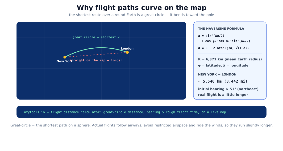
A flight from New York to London arcs north over Canada and the Atlantic instead of running straight across, and it’s not avoiding anything. That curve is the shortest route. The straight line you’d draw between the two cities on a flat map is actually longer. The map is what’s misleading, not the flight path.
The globe problem
You cannot flatten a sphere onto a rectangle without stretching it somewhere, a fact of geometry, not a flaw in any particular map. The familiar Mercator-style world map keeps compass directions tidy but pays for it by stretching everything toward the poles: Greenland looks as big as Africa, though Africa is roughly fourteen times larger by area.
That same stretching is why a flight path looks curved. The route hasn’t changed, the map has pulled the high-latitude middle of the journey sideways, so the genuinely-shortest path ends up drawn as an arc bending toward the pole. Switch to a globe, or to a projection centred on your route (an azimuthal or gnomonic one), and the same path snaps back to a straight line. On a gnomonic projection every great circle is drawn dead straight, which is precisely why navigators historically used gnomonic charts to plot the shortest course, then transferred it onto a Mercator chart to steer by.
The takeaway: “curved” and “straight” are properties of the map, not of the journey. The Earth doesn’t know which projection you’re looking at.
What a great circle actually is
A great circle is any circle drawn on the globe whose centre coincides with the centre of the Earth, the largest circle you can draw on the surface. Slice an orange exactly through its middle and the cut edge is a great circle; slice it off-centre and you get a smaller circle.
The equator is a great circle, and so is every line of longitude (each pairs with the one on the far side of the planet to make a full circle through both poles). Lines of latitude, though, apart from the equator, are not great circles, which is exactly why flying “straight east” along a latitude line isn’t the shortest way east.
For any two points on the globe, there’s one great circle passing through them (unless they’re exactly antipodal, in which case infinitely many pass through, every route from the North Pole to the South Pole is equally short). The shorter arc of that circle is the shortest possible path between the two points. That’s the route aircraft aim to fly.
A great circle also has a property that surprises people: its bearing changes constantly along the way. Set off from New York toward London and your initial heading is about 51° (northeast); by the time you approach London you’re heading closer to due east, around 100°. A route that held a fixed compass bearing the whole way, a rhumb line, would trace a different, gently spiralling path that is longer. That trade-off is worth a closer look.
Great circle versus rhumb line
Before satellite navigation, sailors often preferred a rhumb line: holding one compass heading is far easier than continually adjusting course. It costs extra distance, and the penalty grows the longer and more poleward the trip. Over a short hop the two paths are almost identical; over an ocean at high latitude they diverge sharply.
| Path type | What it is | Bearing | Distance | When it’s used |
|---|---|---|---|---|
| Great circle | Shortest arc over the sphere | Changes continuously | Shortest possible | Long-haul flights, modern navigation |
| Rhumb line (loxodrome) | Constant compass heading | Fixed the whole way | Longer than great circle | Simple manual steering, short legs |
For New York to London the great circle runs about 5,540 km; a rhumb line between the same two airports is only modestly longer, because both cities sit at similar latitudes. Push the endpoints toward the poles, or make the east, west gap larger, and the gap between the two paths widens quickly.
How the distance is calculated
Given each place’s latitude (φ) and longitude (λ), the standard tool is the haversine formula, which handles the spherical geometry cleanly:
a = sin²(Δφ/2) + cos φ₁ · cos φ₂ · sin²(Δλ/2)
d = R · 2 · atan2(√a, √(1−a))
Here Δφ and Δλ are the differences in latitude and longitude, φ₁ and φ₂ are the two latitudes, and R is the Earth’s mean radius, 6,371 km. The result d is the great-circle distance. For New York (JFK) to London (LHR) it comes out at about 5,540 km (3,442 miles), on an initial bearing of roughly 51°, northeast, which is why the route heads up over the Atlantic.
A worked example
Take JFK at latitude 40.64°N, longitude 73.78°W, and Heathrow at 51.47°N, 0.46°W. The differences are Δφ ≈ 10.83° and Δλ ≈ 73.32°. Feed those (converted to radians) into the haversine expression and the intermediate value a works out to roughly 0.189; the angular distance 2·atan2(√a, √(1−a)) is about 0.869 radians. Multiply by R = 6,371 km and you get ≈ 5,540 km. That single angle-times-radius step is the whole trick: haversine’s job is just to turn two lat/long pairs into that central angle reliably, even for points very close together where a naïve cosine formula loses precision.
Why not just use the cosine rule?
The older spherical law of cosines gives the same great-circle answer in one line. It’s mathematically fine but numerically fragile: for two points only metres apart, rounding error in the cosine can spit out nonsense. Haversine was popularised precisely because it stays accurate at small distances. For the last word in precision on the real, slightly-squashed Earth, geodesists use Vincenty’s formulae or the more robust Karney algorithm on the WGS-84 ellipsoid.
| Method | Earth model | Typical accuracy | Best for |
|---|---|---|---|
| Law of cosines | Sphere | Good, but poor for short distances | Quick back-of-envelope |
| Haversine | Sphere | Within ~0.5% of true distance | Travel, mapping, everyday use |
| Vincenty | Ellipsoid (WGS-84) | Sub-metre | Surveying, geodesy |
| Karney (geodesics) | Ellipsoid (WGS-84) | Sub-millimetre, always converges | Reference-grade computation |
The haversine assumes a perfectly round Earth. The real planet is very slightly flattened, the equatorial radius is about 21 km larger than the polar radius, so the spherical answer sits within roughly half a percent of the true figure. That’s irrelevant for planning a trip: on the New York, London route, half a percent is about 25 km, a rounding error next to the detours real flights already make.
Routes that look wrong but aren’t
The clearest proof that great circles are real is the set of routes that look absurd on a wall map yet are genuinely shortest. Flights between the northern United States and East Asia arc up toward the Arctic because, for cities that far north, the great circle passes near the pole. Chicago to Beijing crossing close to the North Pole isn’t a scenic detour, flattened onto a rectangular map, the shortest path simply has to bow that far north.
Here are a few well-known long-haul pairs and their approximate great-circle distances, to show how quickly “as the crow flies” adds up over a round planet:
| Route | Approx. great-circle distance | Notes |
|---|---|---|
| New York → London | ~5,540 km (~3,440 mi) | Classic transatlantic; bends north over Canada |
| Los Angeles → Tokyo | ~8,800 km (~5,460 mi) | Follows the northern Pacific rim |
| Chicago → Beijing | ~10,600 km (~6,590 mi) | Passes close to the North Pole |
| Dubai → New York | ~11,000 km (~6,840 mi) | Arcs high over the North Atlantic |
| Sydney → Los Angeles | ~12,050 km (~7,490 mi) | Long southern-to-northern Pacific crossing |
Distances are rounded and vary slightly with the exact airports used, but each one is the shortest path a sphere allows, not the straight line a flat map would tempt you to draw.
Why the real flight is a bit longer
The great-circle distance is the theoretical shortest path. Actual flights are a little longer for practical reasons:
- Airways and air-traffic control, planes follow published corridors and are sequenced by controllers, not sent along a mathematical ideal.
- Restricted airspace, conflict zones, military areas and closed regions force detours.
- Winds, riding a tailwind (or dodging a headwind, like the jet stream) can be worth flying some extra distance, because it saves time and fuel overall.
So the great-circle figure is the floor: the shortest it could possibly be, with reality adding a modest amount on top.
See it for your own route
The flight distance calculator draws the great-circle line between any two cities on a world map and reads off the distance in kilometres, miles and nautical miles, along with the bearing and a rough flight time. From there the flight time calculator turns a distance into an estimated duration, and the jet lag calculator tells you how long the time-zone shift is likely to take to shake off. Like every LazyTools tool, they run entirely in your browser, no location access, nothing uploaded.
Distances use the haversine great-circle formula on a mean Earth radius of 6,371 km (the IUGG mean). Great-circle distance is the shortest path over a spherical Earth; actual flight routes are longer because of airways, airspace restrictions and winds. Sources: Great-circle distance (Wikipedia), Movable Type, distance & bearing between lat/long points.
Frequently asked questions
Why do flights take a curved path instead of a straight line?
They actually take the straightest possible path over the round Earth, a great circle. It only looks curved because a flat map stretches the globe, especially near the poles. The straight line you'd draw on the map is really a longer route.
What is a great-circle distance?
The shortest distance between two points on a sphere, measured along the circle whose centre is the centre of the Earth. The equator and any line of longitude are great circles; lines of latitude (except the equator) are not.
How is flight distance between two cities calculated?
From the two cities' latitude and longitude using the haversine formula, which gives the great-circle distance on a sphere of mean radius 6,371 km. It's the standard method for straight-line ('as the crow flies') distance.
Why is the actual flight longer than the great-circle distance?
Because aircraft follow published airways, detour around restricted or stormy airspace, and route to catch tailwinds or dodge headwinds. The great-circle distance is the theoretical shortest path, so real routes are a bit longer.
Is 'as the crow flies' the same as great-circle distance?
Essentially yes, both mean the shortest straight-line path between two points, ignoring roads or air routes. Over long distances 'straight' has to follow the curve of the Earth, which is exactly the great circle.
Why do some flights fly over the Arctic?
Because for cities at high northern latitudes the great circle passes near the pole. A route like Chicago to Beijing is genuinely shortest going almost over the North Pole, even though on a flat map that looks like a wild detour.
How accurate is the haversine formula?
It assumes a perfect sphere, so it's within about 0.5% of the true distance on the slightly-flattened Earth, more than accurate enough for travel. Survey-grade work uses the Vincenty or Karney method on the WGS-84 ellipsoid instead.