
explainer
WKT vs GeoJSON: Two Ways to Write a Geometry (and How to Convert)
By Uttam Regmi · Published 2026-08-03 · Updated 2026-08-23 · 6 min read · Fact-checked, sources cited
WKT and GeoJSON both describe the same shapes, points, lines, polygons, but they live in different worlds: WKT in spatial databases, GeoJSON on web maps. Knowing how each works (and the one coordinate gotcha they don’t disagree on) makes moving geometry between a database and a map painless. Here’s the comparison, with converters for WKT → GeoJSON and GeoJSON → WKT.
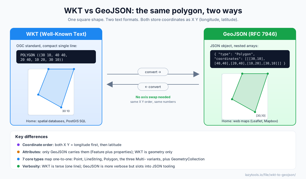
The same polygon, two ways
Here’s one square written in each format:
WKT:
POLYGON ((30 10, 40 40, 20 40, 10 20, 30 10))GeoJSON:
{ "type": "Polygon",
  "coordinates": [[[30,10],[40,40],[20,40],[10,20],[30,10]]] }
Same geometry, WKT is a compact line, GeoJSON is structured JSON. That difference is the whole story of when to use which. Here is the comparison at a glance:
| Aspect | WKT | GeoJSON |
|---|---|---|
| Standard | OGC Simple Features (Well-Known Text) | RFC 7946 |
| Syntax | Type keyword + parenthesised coordinates | JSON object with type and coordinates |
| Coordinate order | X Y (longitude, latitude) | X Y (longitude, latitude) |
| Carries attributes? | No, geometry only | Yes, via Feature / properties |
| Typical home | Spatial databases, SQL functions | Web maps, JavaScript, APIs |
| Reads well to | Databases and humans scanning a query | Browsers and JSON tooling |
| Verbosity | Terse, single line | More verbose, nested |
WKT wins on brevity; GeoJSON wins on fitting into the JSON world and carrying data alongside the shape. Neither is “better”. They are optimised for different destinations, and most real workflows use both.
WKT: compact text for databases
Well-Known Text is an OGC standard: a geometry type keyword followed by parenthesised coordinates.
POINT (30 10)
LINESTRING (30 10, 10 30, 40 40)
POLYGON ((35 10, 45 45, 15 40, 10 20, 35 10), (20 30, 35 35, 30 20, 20 30))   ← with a hole
MULTIPOLYGON (((…)), ((…)))
GEOMETRYCOLLECTION (POINT (40 10), LINESTRING (10 10, 20 20))
Read it left to right: the keyword names the shape, and the coordinates follow inside parentheses. A
POINT needs one coordinate pair; a LINESTRING needs a comma-separated list of pairs; a POLYGON
wraps each ring in its own parentheses, with the first ring being the outer boundary and any later rings
being holes cut out of it. Every ring is closed, its last coordinate repeats its first, which is why the
square above ends where it began, back at 30 10.
It’s what PostGIS and other spatial SQL expect: ST_GeomFromText('POINT(30 10)'). Because it is a
single line of plain text, WKT drops cleanly into a SQL statement, a CSV cell, or a log line without any
escaping. That compactness is exactly why databases favour it, but it comes with a trade-off: WKT stores
geometry only. There is no slot for a name, an ID, a timestamp, or any other attribute. If you need to
keep those, they live somewhere else, typically in the other columns of the same database row.
A close cousin, WKB (Well-Known Binary), encodes the identical model as bytes rather than text; it is what spatial databases usually store internally for speed and precision, while WKT is the human-readable face you see in a query.
GeoJSON: JSON for the web
GeoJSON (RFC 7946) expresses the same geometries as JSON objects, which is why every web-mapping
library speaks it. It also adds a layer WKT lacks: a Feature wraps a geometry with a properties
object, and a FeatureCollection groups many Features, so GeoJSON can carry both the shape and its
data.
{ "type": "Feature",
  "geometry": { "type": "Point", "coordinates": [30, 10] },
  "properties": { "name": "Depot" } }
That properties object is the big practical difference. In a FeatureCollection you can hand a mapping
library a set of shapes and the label, category, or value each one should render with, all in one file.
RFC 7946 also pins down a few details worth knowing: coordinates are expected in the WGS 84 datum
(plain longitude/latitude degrees), and while a position may include a third number for elevation, the
first two are always longitude then latitude.
The seven geometry types, side by side
Both formats describe the same core set of geometry types, and they translate one-to-one. This mapping is the whole basis of a lossless conversion:
| Geometry | WKT | GeoJSON type |
|---|---|---|
| Single point | POINT (…) | Point |
| Path / line | LINESTRING (…) | LineString |
| Area (with optional holes) | POLYGON ((…)) | Polygon |
| Many points | MULTIPOINT (…) | MultiPoint |
| Many lines | MULTILINESTRING (…) | MultiLineString |
| Many areas | MULTIPOLYGON (((…))) | MultiPolygon |
| Mixed bag | GEOMETRYCOLLECTION (…) | GeometryCollection |
Because every row lines up, a converter never has to guess or drop a shape, a WKT MULTIPOLYGON becomes
a GeoJSON MultiPolygon with the same rings, and back again.
The coordinate-order gotcha (that isn’t one, here)
The classic mapping bug is latitude/longitude order, many APIs and humans say “lat, lon,” but these two formats do not. Both WKT and GeoJSON use X Y = longitude, latitude:
- WKT
POINT (30 10)→ longitude 30, latitude 10. - GeoJSON
[30, 10]→ longitude 30, latitude 10.
Because they agree, converting between WKT and GeoJSON needs no axis swapping, a relief compared with formats like GPS/GPX that put latitude first. (If a map shows your points in the ocean off Africa near 0°, 0°, “Null Island”, it’s usually because something else swapped the order or dropped a value.)
A worked round-trip
Say a PostGIS query returns a triangular delivery zone as WKT:
POLYGON ((-0.13 51.51, -0.10 51.52, -0.11 51.49, -0.13 51.51))To draw it on a Leaflet map, convert it to GeoJSON. The keyword POLYGON becomes "type": "Polygon", the
single ring becomes one nested array, and each x y pair becomes an [x, y] array, with no numbers
touched:
{ "type": "Polygon",
  "coordinates": [[[-0.13,51.51],[-0.10,51.52],[-0.11,51.49],[-0.13,51.51]]] }
Draw a revised zone on that map, and Leaflet hands you GeoJSON back. Convert it to WKT to UPDATE the row,
and you are exactly where you started, same order, same closing coordinate, same shape. The only thing
that would not survive a trip through WKT is a properties block, because WKT has nowhere to put it.
Converting between them
Moving geometry around is routine: a spatial query hands you WKT, and you convert it to GeoJSON to render on a Leaflet or Mapbox map, or you draw a shape on a web map, get GeoJSON, and convert it to WKT to store in PostGIS. Two things to remember:
- Coordinate order is preserved (both are X Y), so the shape stays put.
- Properties don’t survive the trip to WKT, WKT holds geometry only, so keep attributes separately.
Both WKT → GeoJSON and GeoJSON → WKT run entirely in your browser: paste a geometry and copy the result, with points, lines, polygons (including holes), the multi-variants and geometry collections all handled, and your location data never leaving your device.
Frequently asked questions
What is the difference between WKT and GeoJSON?
They describe the same geometries but in different syntaxes for different homes. WKT (Well-Known Text) is a compact, single-line text format from the OGC used by spatial databases like PostGIS, e.g. POINT (30 10). GeoJSON (RFC 7946) is a JSON format used across web mapping (Leaflet, Mapbox, OpenLayers), e.g. {"type":"Point","coordinates":[30,10]}. WKT is terser; GeoJSON slots into JSON tooling and can carry feature properties.
Do WKT and GeoJSON use the same coordinate order?
Yes, both use X Y order, meaning longitude first then latitude. So a WKT POINT (30 10) and a GeoJSON [30, 10] both mean longitude 30, latitude 10. This is a common source of bugs because some other formats and mapping APIs (and everyday speech) put latitude first; WKT and GeoJSON agree on longitude-first.
How do I convert WKT to GeoJSON?
Parse the WKT geometry and emit the equivalent GeoJSON object: POINT becomes a Point, POLYGON becomes a Polygon with its rings, and so on, keeping the coordinates in the same X Y order. A converter does this instantly; because both formats share coordinate order, no axis swapping is involved.
Does WKT support polygon holes and multi-geometries?
Yes. A WKT polygon can have an outer ring plus inner rings (holes), written as POLYGON ((outer…), (hole…)), and there are MULTIPOINT, MULTILINESTRING, MULTIPOLYGON and GEOMETRYCOLLECTION types, all of which map directly to the corresponding GeoJSON geometry types.
Can WKT store feature attributes like GeoJSON?
No, WKT encodes geometry only. GeoJSON can wrap a geometry in a Feature with a properties object, so it carries attributes too. When you convert GeoJSON to WKT the geometry is preserved but any properties are dropped; keep them separately (for example in the database row alongside the WKT).
Which format should I use?
Use WKT when talking to spatial databases and SQL functions (PostGIS ST_GeomFromText, spatial indexes). Use GeoJSON for web maps and anything JSON-based. Many workflows move between them, a query returns WKT, and you convert it to GeoJSON to display on a Leaflet map, which is exactly what a converter is for.